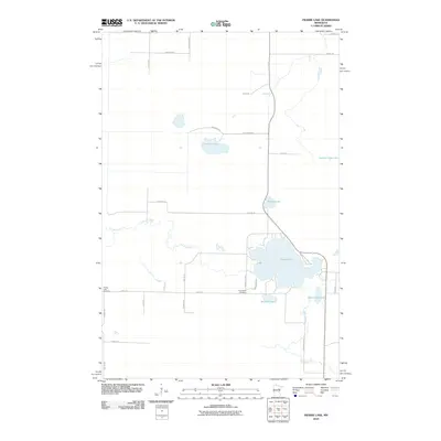
2010 Map of Prairie Lake
USGS Topo · Published 2010About this map
Prairie Lake and its surrounding wetlands anchor this part of Carlton County, where the meandering course of the Prairie River weaves through a landscape defined by glacial lakes and small streams. The 2010 survey highlights a quiet, rural character with low-density settlement concentrated along secondary routes like Graff Rd and Prairie Lake Rd. For those researching family history or local land use, the map identifies two significant community landmarks: Prairie Lake Cemetery in the west and Fine Lakes Cemetery further east near the lake. The topography is dotted with smaller water bodies such as Meander Lake, Blackwood Lake, and Moberg Lake, while Hasty Brook drains the southern territory. This map documents a stable northern Minnesota landscape where the primitive road network remains primarily unchanged from the mid-20th century, serving as a baseline for environmental and genealogical study.
Find a feature on this map
31 named features on this map. Tap any name to fly to it.
Don’t see what you’re looking for? This feature index may not catch every label — zoom into the map to look around manually.
Map Details
Editions of this 2010 Prairie Lake Map
This is the sole edition of this map. No revisions or reprints were ever made.
Other maps of this area

1953 · Duluth
USGS Topo · 1:250,000

1958 · Duluth
USGS Topo · 1:250,000

1961 · Cromwell
USGS Topo · 1:62,500

1963 · Gowan
USGS Topo · 1:24,000

1963 · Prairie Lake
USGS Topo · 1:24,000
1963 · Mc Carty River
USGS Topo · 1:24,000
1963 · Floodwood
USGS Topo · 1:24,000

1969 · Island
USGS Topo · 1:24,000

1970 · Little Prairie Lake
USGS Topo · 1:24,000

1970 · Wright
USGS Topo · 1:24,000