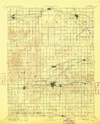
1894 Map of Pratt
USGS Topo · Published 1913About this map
The North Fork of Ninnescah River and South Fork Ninnescah River converge toward the east of this survey, defining a prairie landscape at a peak of late-19th-century railroad expansion. Pratt and Stafford serve as primary hubs, connected by an intricate web of iron including the Atchison Topeka and Santa Fe Railroad, the Missouri Pacific Railroad, and the Chicago Kansas and Nebraska Railroad.
Find a feature on this map
48 named features on this map. Tap any name to fly to it.
Don’t see what you’re looking for? This feature index may not catch every label — zoom into the map to look around manually.
Map Details
Editions of this 1894 Pratt Map
5 editions found

Other maps of this area

1889 · Anthony
USGS Topo · 1:125,000

1889 · Larned
USGS Topo · 1:125,000

1889 · Kinsley
USGS Topo · 1:125,000

1891 · Great Bend
USGS Topo · 1:125,000

1891 · Medicine Lodge
USGS Topo · 1:125,000

1891 · Larned
USGS Topo · 1:125,000

1891 · Anthony
USGS Topo · 1:125,000

1892 · Kinsley
USGS Topo · 1:125,000

1892 · Kingman
USGS Topo · 1:125,000

1892 · Coldwater
USGS Topo · 1:125,000