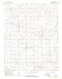
1968 Map of Pratt SE
USGS Topo · Published 1970About this map
The broad floor of McPherson Valley dominates this prairie landscape southeast of Pratt during the late 1960s. The topography is defined by the headwaters of the Chikaskia River and its tributaries, Painter Creek and Sand Creek, which cut through the high plains. Industrial activity is concentrated in the northwest at the Chitwood Oil Field and along the various pipelines that traverse the township lines. Local social life is anchored by the Ashton Community Hall, a notable landmark for genealogists tracing rural community hubs in this part of Kansas. The map also delineates land divisions including Paxon and Grove, illustrating the organized grid of agriculture and extraction that shaped the region's mid-century development.
Find a feature on this map
11 named features on this map. Tap any name to fly to it.
Don’t see what you’re looking for? This feature index may not catch every label — zoom into the map to look around manually.
Map Details
Editions of this 1968 Pratt SE Map
This is the sole edition of this map. No revisions or reprints were ever made.
Other maps of this area

1889 · Anthony
USGS Topo · 1:125,000

1891 · Medicine Lodge
USGS Topo · 1:125,000

1891 · Anthony
USGS Topo · 1:125,000

1892 · Kingman
USGS Topo · 1:125,000

1892 · Pratt
USGS Topo · 1:125,000

1893 · Medicine Lodge
USGS Topo · 1:125,000

1894 · Kingman
USGS Topo · 1:125,000

1894 · Pratt
USGS Topo · 1:125,000

1955 · Pratt
USGS Topo · 1:250,000

1959 · Pratt
USGS Topo · 1:250,000