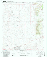
1973 Map of Prescott Valley North
USGS Topo · Published 1991About this map
Lonesome Valley dominates this 1973 topographical survey, showcasing a broad arid basin before the intensive residential expansion of later decades. The southern edge of the map reveals the early footprint of Prescott Valley, where a budding street network including Robert Road and Mountain View Road begins to climb away from the Agua Fria River. This period of the town's development is characterized by sparse infrastructure and a reliance on water catchment features like Black Hill Tank and Midway Tank. To the east, the terrain rises into the Prescott National Forest, where the Old Hopkins Mine and several prospects indicate the region's enduring relationship with mineral extraction. The map also clearly delineates the Gila and Salt River Meridian, a critical surveying line that bisects the landscape and dictates the geometric grid of modern land ownership in the high desert.
Find a feature on this map
21 named features on this map. Tap any name to fly to it.
Don’t see what you’re looking for? This feature index may not catch every label — zoom into the map to look around manually.
Map Details
Editions of this 1973 Prescott Valley North Map
3 editions found
Other maps of this area

1887 · Prescott
USGS Topo · 1:250,000

1892 · Prescott
USGS Topo · 1:250,000

1905 · Jerome
USGS Topo · 1:125,000

1944 · Clarkdale
USGS Topo · 1:48,000

1944 · Mingus Mountain
USGS Topo · 1:62,500

1947 · Mingus Mtn
USGS Topo · 1:62,500

1947 · Paulden
USGS Topo · 1:62,500

1947 · Prescott
USGS Topo · 1:62,500

1948 · Prescott
USGS Topo · 1:62,500
1948 · Clarkdale
USGS Topo · 1:62,500