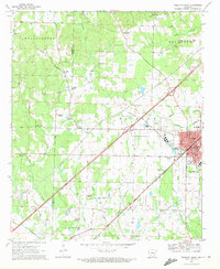
1970 Map of Prescott West
USGS Topo · Published 1972About this map
Prescott serves as the focal point of this Nevada County landscape, situated at the junction of the Missouri Pacific and Prescott and Northwestern railroads. This 1970 survey illustrates a developed civic infrastructure including the Courthouse, a Hospital, and the County Fairground, while the surrounding rural areas are marked by a high density of country churches and family-named cemeteries. These sites, such as Beards Chapel Cem and De Ann Cem, reveal the long-standing community roots that persist alongside industrial elements like multiple pipelines and an aqueduct.
Find a feature on this map
53 named features on this map. Tap any name to fly to it.
Don’t see what you’re looking for? This feature index may not catch every label — zoom into the map to look around manually.
Map Details
Editions of this 1970 Prescott West Map
2 editions found
Other maps of this area

1901 · Gurdon
USGS Topo · 1:125,000

1951 · Blevins
USGS Topo · 1:24,000

1951 · Pisgah
USGS Topo · 1:24,000

1951 · Hope
USGS Topo · 1:24,000

1953 · El Dorado
USGS Topo · 1:250,000

1957 · El Dorado
USGS Topo · 1:250,000

1958 · El Dorado
USGS Topo · 1:250,000

1960 · El Dorado
USGS Topo · 1:250,000

1970 · Prescott East
USGS Topo · 1:24,000
1970 · Okolona South
USGS Topo · 1:24,000