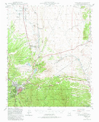
1947 Map of Prescott
USGS Topo · Published 1980About this map
Prescott serves as the focal point of this late 1940s landscape, flanked by the sprawling Whipple Military Reservation and the Yavapai Ind Res. The map documents a period when the Atchison Topeka and Santa Fe railroad line provided the primary pulse for northern Arizona commerce, connecting smaller outposts like Granite Siding and Entro to the regional hub. The geography is defined by the sharp transition from the granite basins of Granite Dells and the waters of Watson L to the high elevations of Prescott National Forest. To the northeast, the Little Chino Valley irrigation network reflects early water management efforts, while names like Fain Ranch and Storm Ranch suggest the area's deep-rooted ranching heritage during this mid-century era.
Find a feature on this map
54 named features on this map. Tap any name to fly to it.
Don’t see what you’re looking for? This feature index may not catch every label — zoom into the map to look around manually.
Map Details
Editions of this 1947 Prescott Map
3 editions found

Other maps of this area

1887 · Prescott
USGS Topo · 1:250,000

1892 · Prescott
USGS Topo · 1:250,000

1903 · Bradshaw Mountains
USGS Topo · 1:125,000

1903 · Congress
USGS Topo · 1:125,000

1904 · Congress
USGS Topo · 1:125,000

1905 · Jerome
USGS Topo · 1:125,000

1944 · Clarkdale
USGS Topo · 1:48,000

1944 · Mingus Mountain
USGS Topo · 1:62,500

1947 · Mingus Mtn
USGS Topo · 1:62,500

1947 · Mayer
USGS Topo · 1:62,500