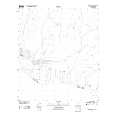
2010 Map of Presidio East
USGS Topo · Published 2010About this map
Fort Leaton stands as a primary landmark along the Rio Grande corridor in this borderlands survey. The map details the eastern expansion of Presidio, where residential streets like Santa Fe Blvd and Park Valley Ave meet the desert landscape. To the southeast, the small settlement of Campo Santo Estrada sits near the river, while the Casa Blanca Cemetery serves the local population near Loma Pelona. The terrain is defined by a series of drainage systems, including Cibolo Creek and Alamito Creek, which cut through the arid flats to reach the international boundary. This map captures the intersection of rural Texas life and the geographic reality of the border, where long-standing landmarks and newer residential developments coexist alongside the natural paths of the arroyos.
Find a feature on this map
35 named features on this map. Tap any name to fly to it.
Don’t see what you’re looking for? This feature index may not catch every label — zoom into the map to look around manually.
Map Details
Editions of this 2010 Presidio East Map
This is the sole edition of this map. No revisions or reprints were ever made.
Other maps of this area

1896 · Polvo
USGS Topo · 1:125,000

1896 · Shafter
USGS Topo · 1:125,000

1959 · Presidio
USGS Topo · 1:250,000

1965 · Presidio
USGS Topo · 1:250,000
1971 · Redford
USGS Topo · 1:24,000

1978 · La Boquilla
USGS Topo · 1:24,000
1979 · Presidio West
USGS Topo · 1:24,000

1979 · Presidio East
USGS Topo · 1:24,000

1980 · Arroyo Melado
USGS Topo · 1:24,000

1983 · Cerro Redondo
USGS Topo · 1:24,000