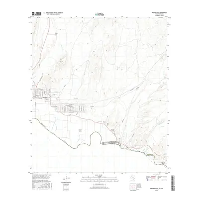
2016 Map of Presidio East
USGS Topo · Published 2016About this map
Presidio sits at the international boundary where the winding Rio Grande separates the United States of America from Mexico. The town's layout reflects its growth along the river basin, with residential streets like Rosedale St and Commerce St branching off from the primary transit corridors of Us 67 and FM 170. The surrounding landscape is defined by the high-desert drainage systems of the Big Bend region, featuring numerous seasonal waterways such as Cibolo Creek and Alamito Creek. Local history is anchored by the Presidio Cemetery and the more remote Casa Blanca Cemetery near Arroyo Arenoso. The map details the complex terrain of the Chihuahuan Desert, where landmarks like Loma Pelona and Casa Piedra rise above the alluvial fans of Arroyo Tortola and Arroyo Galindo.
Find a feature on this map
65 named features on this map. Tap any name to fly to it.
Don’t see what you’re looking for? This feature index may not catch every label — zoom into the map to look around manually.
Map Details
Editions of this 2016 Presidio East Map
This is the sole edition of this map. No revisions or reprints were ever made.
Other maps of this area

1896 · Polvo
USGS Topo · 1:125,000

1896 · Shafter
USGS Topo · 1:125,000

1959 · Presidio
USGS Topo · 1:250,000

1965 · Presidio
USGS Topo · 1:250,000
1971 · Redford
USGS Topo · 1:24,000

1978 · La Boquilla
USGS Topo · 1:24,000
1979 · Presidio West
USGS Topo · 1:24,000

1979 · Presidio East
USGS Topo · 1:24,000

1980 · Arroyo Melado
USGS Topo · 1:24,000

1983 · Cerro Redondo
USGS Topo · 1:24,000