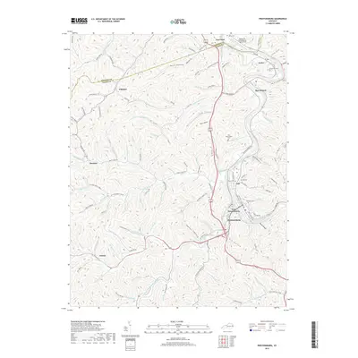
2019 Map of Prestonsburg
USGS Topo · Published 2019About this map
Prestonsburg sits at the confluence of several major waterways, anchored by the Levisa Fork and the mouth of Middle Cr Levisa Fork. The town's layout reflects its evolution as a regional hub, with West Prestonsburg and Cliff expanding across the river from the historic core. This 2019 survey documents a landscape where steep hollows like Bear Hollow and Travis Hollow dictate the narrow corridors of settlement. The northern reaches of the map show the industrial and transportation corridor between East Point and Auxier, including the Paintsville-Prestonsburg Combs Field. For those researching family history in Floyd County, the map provides precise locations for several named burial grounds, including the Governors Cem, Music Cem, and the uniquely named Van Burenvaughn Cem. The rural landscape is further defined by scattered hamlets such as Whitaker and Bonanza, which remain connected by a network of winding hollow roads like Hager Paint Branch Rd.
Find a feature on this map
92 named features on this map. Tap any name to fly to it.
Don’t see what you’re looking for? This feature index may not catch every label — zoom into the map to look around manually.
Map Details
Editions of this 2019 Prestonsburg Map
This is the sole edition of this map. No revisions or reprints were ever made.
Other maps of this area

1886 · Prestonsburg
USGS Topo · 1:125,000

1892 · Prestonsburg
USGS Topo · 1:125,000

1914 · Laynesville
USGS Topo · 1:48,000

1914 · Inez
USGS Topo · 1:48,000

1915 · Paintsville
USGS Topo · 1:48,000

1915 · Prestonsburg
USGS Topo · 1:62,500

1916 · Harold
USGS Topo · 1:62,500

1916 · Inez
USGS Topo · 1:62,500

1917 · Paintsville
USGS Topo · 1:62,500

1918 · Prestonsburg
USGS Topo · 1:62,500