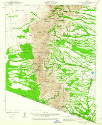
1941 Map of Presumido Peak
USGS Topo · Published 1941About this map
The Baboquivari Mountains dominate this 1941 landscape, a rugged borderland where the high peaks of Aguirre Peak and Presumido Peak overlook a network of washes and high-desert ranching outposts. Along the southern boundary, the United States Mexico border is anchored by the settlement of Sasabe, where a U S Customs station stands near the Rancho de la Osa. The map records a transition between the Baboquivari Indian Reservation to the west and the expansive valley flats to the east, marked by isolated features like the Site of Old Indian Fort near Nachi Kulik. Cattle ranching was the primary engine of this remote economy, evidenced by the numerous named properties such as Santa Margarita Ranch, Buenos Aires Ranch, and the Presumido Store. Water remains a central theme in this arid environment, traced through intermittent flows like Hondo Wash and the presence of rare catchments such as Aguirre Lake and Mormon Lake.
Find a feature on this map
63 named features on this map. Tap any name to fly to it.
Don’t see what you’re looking for? This feature index may not catch every label — zoom into the map to look around manually.
Map Details
Editions of this 1941 Presumido Peak Map
2 editions found
Other maps of this area

1920 · Arivaca
USGS Topo · 1:125,000

1921 · Old Glory
USGS Topo · 1:125,000

1940 · Palo Alto Ranch
USGS Topo · 1:62,500

1941 · Presumido Peak
USGS Topo · 1:62,500

1941 · Baboquivari Peak
USGS Topo · 1:62,500

1941 · Arivaca
USGS Topo · 1:62,500

1941 · Vamori
USGS Topo · 1:62,500

1941 · Sells
USGS Topo · 1:62,500

1942 · Oro Blanco
USGS Topo · 1:62,500

1943 · Sells
USGS Topo · 1:62,500