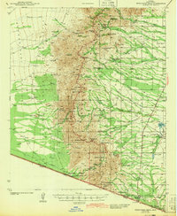
1943 Map of Presumido Peak
USGS Topo · Published 1943About this map
Sasabe sits at the southern edge of this Arizona landscape, positioned right at the United States Mexico border where a U.S. Customs post marks the crossing into Arizona Sonora. This 1941 survey captures a ranching-heavy corridor dominated by family-named operations like the Santa Margarita Ranch, Aros Ranch, and Los Avispas Ranch. The terrain is characterized by the broad Baboquivari Valley and Alameda Valley, punctuated by sharp rises such as Presumido Peak and Aguirre Peak.
Find a feature on this map
72 named features on this map. Tap any name to fly to it.
Don’t see what you’re looking for? This feature index may not catch every label — zoom into the map to look around manually.
Map Details
Editions of this 1943 Presumido Peak Map
2 editions found

Other maps of this area

1920 · Arivaca
USGS Topo · 1:125,000

1921 · Old Glory
USGS Topo · 1:125,000

1940 · Palo Alto Ranch
USGS Topo · 1:62,500

1941 · Presumido Peak
USGS Topo · 1:62,500

1941 · Baboquivari Peak
USGS Topo · 1:62,500

1941 · Arivaca
USGS Topo · 1:62,500

1941 · Vamori
USGS Topo · 1:62,500

1941 · Sells
USGS Topo · 1:62,500

1942 · Oro Blanco
USGS Topo · 1:62,500

1943 · Sells
USGS Topo · 1:62,500