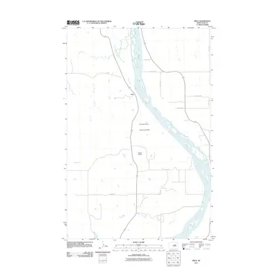
2011 Map of Price
USGS Topo · Published 2011About this map
The Missouri River defines the eastern boundary of this Oliver County landscape, where the small settlement of Price sits positioned along the drainage of Sherk Creek. The terrain is characterized by prominent geological rises that provided natural landmarks for early travelers and residents alike, most notably the Square Buttes, Stonehouse Butte, and Horseshoe Butte. These features rise above the river valley, marking a transition from the riparian environment to the high plains of North Dakota. The map detail reflects a quiet, rural character, dominated by the sweeping curves of the river and the isolated buttes that interrupt the surrounding topography. A sparse grid of local roads, including 80 St NW and 26th St SW, connects the area's agricultural holdings and the central hub of Price to the broader region.
Find a feature on this map
14 named features on this map. Tap any name to fly to it.
Don’t see what you’re looking for? This feature index may not catch every label — zoom into the map to look around manually.
Map Details
Editions of this 2011 Price Map
This is the sole edition of this map. No revisions or reprints were ever made.
Other maps of this area

1907 · Bismarck
USGS Topo · 1:125,000

1950 · Wilton
USGS Topo · 1:62,500

1951 · Bismarck
USGS Topo · 1:62,500

1954 · Bismarck
USGS Topo · 1:250,000

1954 · McClusky
USGS Topo · 1:250,000

1958 · Bismarck
USGS Topo · 1:250,000

1958 · McClusky
USGS Topo · 1:250,000

1962 · Harmon
USGS Topo · 1:24,000
1962 · Burnt Butte
USGS Topo · 1:24,000

1966 · Price
USGS Topo · 1:24,000