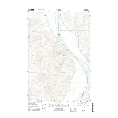
2014 Map of Price
USGS Topo · Published 2014About this map
Price sits along the western bank of the Missouri River, serving as a central point in a landscape defined by the prominent upland formations of the Square Buttes. The terrain here is marked by the distinct elevations of Horseshoe Butte and Stonehouse Butte, which rise sharply from the river valley. The river itself serves as the border between Oliver Co and Burleigh Co, with the waterway’s shifting course reflected in the sandbars and channels charted near the mouth of Sherk Creek. A grid of local roads, such as River Rd and 26th St SW, provides access to the agricultural parcels and high ground above the Missouri floodplain. This 2014 survey records the traditional ranching and farming landscape of central North Dakota before more modern industrial developments significantly altered the surface topography.
Find a feature on this map
20 named features on this map. Tap any name to fly to it.
Don’t see what you’re looking for? This feature index may not catch every label — zoom into the map to look around manually.
Map Details
Editions of this 2014 Price Map
This is the sole edition of this map. No revisions or reprints were ever made.
Other maps of this area

1907 · Bismarck
USGS Topo · 1:125,000

1950 · Wilton
USGS Topo · 1:62,500

1951 · Bismarck
USGS Topo · 1:62,500

1954 · Bismarck
USGS Topo · 1:250,000

1954 · McClusky
USGS Topo · 1:250,000

1958 · Bismarck
USGS Topo · 1:250,000

1958 · McClusky
USGS Topo · 1:250,000

1962 · Harmon
USGS Topo · 1:24,000
1962 · Burnt Butte
USGS Topo · 1:24,000

1966 · Price
USGS Topo · 1:24,000