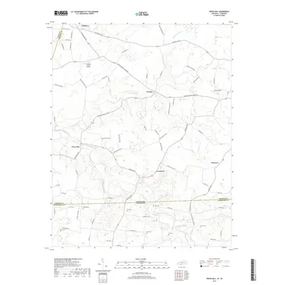
2019 Map of Prices Mill
USGS Topo · Published 2019About this map
Prices Mill stands at a bend in the Red River near the border of Simpson County, Kentucky, and Robertson County, Tennessee. This landscape is defined by the winding course of the river and its many tributaries, including Sulphur Spring Cr and Woolsey Cr. The area is notably dense with small family cemeteries that dot the hillsides between farmsteads, such as Duer Cem, Byram Cem, and Rose Cem. Small rural settlements like Neosheo and Middleton are connected by a network of local roads such as Russellville Rd and Adairville Rd. The presence of landmarks like Cummings Farms Airfield and Welcome Field suggests a region with active private aviation interests integrated into its agricultural base. This survey offers a precise look at the rural geography of the Pennyroyal Plain, capturing the transition from upland ridges to the wet bottomlands of Rovey Swamp and the various branches feeding the Red River.
Find a feature on this map
80 named features on this map. Tap any name to fly to it.
Don’t see what you’re looking for? This feature index may not catch every label — zoom into the map to look around manually.
Map Details
Editions of this 2019 Prices Mill Map
This is the sole edition of this map. No revisions or reprints were ever made.
Other maps of this area

1942 · Gallatin
USGS Topo · 1:100,000

1951 · Adairville
USGS Topo · 1:24,000

1951 · Woodburn
USGS Topo · 1:24,000

1951 · Franklin
USGS Topo · 1:24,000

1951 · Prices Mill
USGS Topo · 1:24,000

1951 · Auburn
USGS Topo · 1:24,000

1952 · Youngville
USGS Topo · 1:24,000

1952 · Dennis
USGS Topo · 1:24,000

1953 · Orlinda
USGS Topo · 1:24,000
1956 · Portland
USGS Topo · 1:24,000