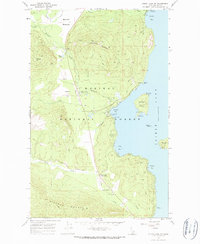
1967 Map of Priest Lake SW
USGS Topo · Published 1972About this map
Kaniksu National Forest defines the rugged western shoreline of Priest Lake in the late 1960s, a period when this region of Idaho balanced a growing recreational identity with its wilderness heritage. The settlement at Vans Corner served as a central hub for the community, anchored by the Priest Lake Sch, while the Priest Lake Ranger Station and Priest Lake Airstrip highlight the infrastructure required for forest management and fire protection.
Find a feature on this map
40 named features on this map. Tap any name to fly to it.
Don’t see what you’re looking for? This feature index may not catch every label — zoom into the map to look around manually.
Map Details
Editions of this 1967 Priest Lake SW Map
2 editions found
Other maps of this area

1901 · Sandpoint
USGS Topo · 1:125,000

1911 · Priest Lake
USGS Topo · 1:250,000

1911 · Sandpoint
USGS Topo · 1:125,000

1913 · Priest Lake
USGS Topo · 1:250,000

1934 · Metaline
USGS Topo · 1:125,000

1936 · Newport
USGS Topo · 1:96,000

1942 · Metaline
USGS Topo · 1:125,000

1942 · Newport
USGS Topo · 1:125,000

1958 · Sandpoint
USGS Topo · 1:250,000

1963 · Sandpoint
USGS Topo · 1:250,000