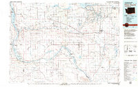
1979 Map of Priest Rapids
USGS Topo · Published 1979About this map
Hanford Works and its dedicated government rail line occupy the southern reach of this landscape, illustrating the significant federal footprint in the region during the late 1970s. The Columbia River serves as the central artery, controlled by the Priest Rapids Dam and the O'Sullivan Dam, which together manage the complex irrigation network of the West Canal and Potholes Canal feeding the Royal Slope. This infrastructure transformed the arid desert into a productive agricultural zone, supporting settlements like Royal City and Othello.
Find a feature on this map
82 named features on this map. Tap any name to fly to it.
Don’t see what you’re looking for? This feature index may not catch every label — zoom into the map to look around manually.
Map Details
Editions of this 1979 Priest Rapids Map
2 editions found
Other maps of this area

1909 · Quincy
USGS Topo · 1:62,500

1910 · Zillah
USGS Topo · 1:125,000

1910 · Quincy
USGS Topo · 1:62,500

1910 · Winchester
USGS Topo · 1:62,500

1911 · Red Rock
USGS Topo · 1:62,500

1912 · Moses Lake
USGS Topo · 1:62,500

1912 · Beverly
USGS Topo · 1:62,500

1915 · Wallulah
USGS Topo · 1:96,000

1915 · Prosser
USGS Topo · 1:125,000

1916 · Connell
USGS Topo · 1:125,000