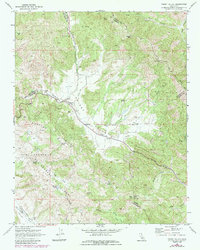
1969 Map of Priest Valley
USGS Topo · Published 1984About this map
Williams Duckworth Cem and Clayton Cem mark the early settlement history of this remote intersection of Monterey, San Benito, and Fresno counties. The North Fork Priest Valley provides a central corridor through the high terrain, where the Priest Valley Sch once served local families in this ranching landscape. To the southwest, the Mustang Ridge and the San Lorenzo Rifle Zone dominate the topography, illustrating the complex faulting and seismic zones typical of the California Coast Ranges. The drainage network is particularly detailed, showing the seasonal flows of Lewis Creek and Charley Creek Valley. These water sources, including numerous small features like Log Cabin Spring and Bear Trap Spring, were essential for sustaining life and livestock in the dry hills of Peachtree Valley during the late 1960s.
Find a feature on this map
38 named features on this map. Tap any name to fly to it.
Don’t see what you’re looking for? This feature index may not catch every label — zoom into the map to look around manually.
Map Details
Editions of this 1969 Priest Valley Map
3 editions found
Other maps of this area

1915 · Priest Valley
USGS Topo · 1:125,000

1941 · Priest Valley
USGS Topo · 1:62,500

1941 · San Ardo
USGS Topo · 1:62,500

1943 · New Idria
USGS Topo · 1:62,500

1943 · San Ardo
USGS Topo · 1:62,500

1943 · Hernandez Valley
USGS Topo · 1:62,500

1944 · Hernandez Valley
USGS Topo · 1:62,500

1944 · Priest Valley
USGS Topo · 1:62,500

1948 · Santa Cruz
USGS Topo · 1:250,000

1955 · Santa Cruz
USGS Topo · 1:250,000