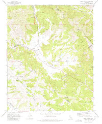
1969 Map of Priest Valley
USGS Topo · Published 1980About this map
San Andreas Rift Zone geological activity defines the landscape of this Monterey County region, where the tectonic boundary dictates the path of Monroe Valley and the alignment of Monroe Lake. The map captures a rural ranching and upland environment at the intersection of Monterey, San Benito, and Fresno counties during the late 1960s. Local history is anchored by the Williams-Duckworth Cem and the Priest Valley Sch near the center of Priest Valley.
Find a feature on this map
40 named features on this map. Tap any name to fly to it.
Don’t see what you’re looking for? This feature index may not catch every label — zoom into the map to look around manually.
Map Details
Editions of this 1969 Priest Valley Map
3 editions found
Other maps of this area

1915 · Priest Valley
USGS Topo · 1:125,000

1941 · Priest Valley
USGS Topo · 1:62,500

1941 · San Ardo
USGS Topo · 1:62,500

1943 · New Idria
USGS Topo · 1:62,500

1943 · San Ardo
USGS Topo · 1:62,500

1943 · Hernandez Valley
USGS Topo · 1:62,500

1944 · Hernandez Valley
USGS Topo · 1:62,500

1944 · Priest Valley
USGS Topo · 1:62,500

1948 · Santa Cruz
USGS Topo · 1:250,000

1955 · Santa Cruz
USGS Topo · 1:250,000