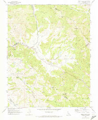
1969 Map of Priest Valley
USGS Topo · Published 1973About this map
The San Lorenzo (Randall) Andreas Rift Zone dominates the southwestern portion of this 1969 survey, tracing a distinct geomorphic line through the landscape. Located at the convergence of Monterey, San Benito, and Fresno counties, the area is defined by the steep rises of Mustang Ridge and the winding course of Lewis Creek through Priest Valley. The map records a sparse settlement pattern of isolated homesteads and public services, including the Priest Valley Sch and the high-elevation Clayton Cem.
Find a feature on this map
44 named features on this map. Tap any name to fly to it.
Don’t see what you’re looking for? This feature index may not catch every label — zoom into the map to look around manually.
Map Details
Editions of this 1969 Priest Valley Map
3 editions found
Other maps of this area

1915 · Priest Valley
USGS Topo · 1:125,000

1941 · Priest Valley
USGS Topo · 1:62,500

1941 · San Ardo
USGS Topo · 1:62,500

1943 · New Idria
USGS Topo · 1:62,500

1943 · San Ardo
USGS Topo · 1:62,500

1943 · Hernandez Valley
USGS Topo · 1:62,500

1944 · Hernandez Valley
USGS Topo · 1:62,500

1944 · Priest Valley
USGS Topo · 1:62,500

1948 · Santa Cruz
USGS Topo · 1:250,000

1955 · Santa Cruz
USGS Topo · 1:250,000