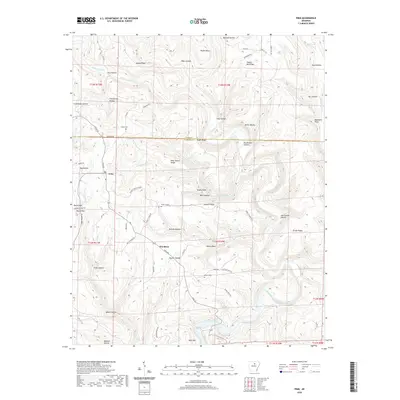
2020 Map of Prim
USGS Topo · Published 2020About this map
Prim and Woodrow serve as the primary focal points of this portion of Cleburne County, where the Ozark foothills are deeply incised by a network of creeks. The landscape is defined by its ridge-and-hollow topography, where names like Pete Turner Ridge, Everett Ridge, and Prince Ridge delineate the high ground above the many winding watercourses. Significant drainage systems such as Panther Skin Creek and Turkey Creek feed into the larger river systems, including the Devils Fork Little Red River in the southeast. Genealogists will find several family-named landmarks and burial grounds, including Knapp Cem near the Stone County line and Everett Cem situated along the ridge that bears the same name. Notable elevations such as Round Mtn and Bear Mtn anchor the terrain, while local routes like Prim Rd and Everett Ridge Rd provide the essential transit framework for these rural communities.
Find a feature on this map
80 named features on this map. Tap any name to fly to it.
Don’t see what you’re looking for? This feature index may not catch every label — zoom into the map to look around manually.
Map Details
Editions of this 2020 Prim Map
This is the sole edition of this map. No revisions or reprints were ever made.
Other maps of this area

1890 · Batesville
USGS Topo · 1:125,000

1891 · Batesville
USGS Topo · 1:125,000

1892 · Mountain View
USGS Topo · 1:125,000

1894 · Mountain View
USGS Topo · 1:125,000

1953 · Memphis
USGS Topo · 1:250,000

1956 · Memphis
USGS Topo · 1:250,000

1956 · Russellville
USGS Topo · 1:250,000

1964 · Russellville
USGS Topo · 1:250,000
1969 · Marcella
USGS Topo · 1:24,000

1969 · Mountain View SW
USGS Topo · 1:24,000