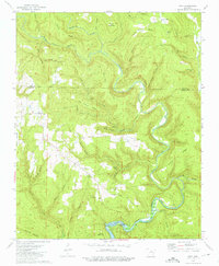
1973 Map of Prim
USGS Topo · Published 1975About this map
The Little Red River and its tributary, the Beech Fork, carve a winding course through this section of the Ozark foothills during the early 1970s. The landscape is defined by long, narrow landforms such as Everett Ridge and Boyer Ridge, which separate numerous hollows. The rural character of the area is centered around the small settlements of Prim and Woodrow, where local life is anchored by institutions like the Woodrow Ch and Signal Hill Ch. The presence of Greers Ferry Lake in the southern portion of the sheet indicates the impact of modern water management on the historical drainage patterns. Genealogists will find several family-named landmarks and resting places, including Signal Hill Cem, Everett Cem, and the Verser Cem near the Ramer Ford.
Find a feature on this map
59 named features on this map. Tap any name to fly to it.
Don’t see what you’re looking for? This feature index may not catch every label — zoom into the map to look around manually.
Map Details
Editions of this 1973 Prim Map
This is the sole edition of this map. No revisions or reprints were ever made.
Other maps of this area

1890 · Batesville
USGS Topo · 1:125,000

1891 · Batesville
USGS Topo · 1:125,000

1892 · Mountain View
USGS Topo · 1:125,000

1894 · Mountain View
USGS Topo · 1:125,000

1953 · Memphis
USGS Topo · 1:250,000

1956 · Memphis
USGS Topo · 1:250,000

1956 · Russellville
USGS Topo · 1:250,000

1964 · Russellville
USGS Topo · 1:250,000
1969 · Marcella
USGS Topo · 1:24,000

1969 · Mountain View SW
USGS Topo · 1:24,000