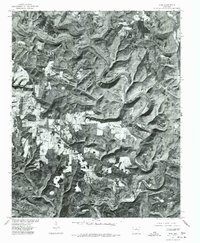
1976 Map of Prim
USGS Topo · Published 1977About this map
Prim and Woodrow anchor this 1970s orthophotoquad, which uses aerial photography to reveal the landscape of Cleburne County with striking clarity. The settlement pattern is defined by small clearings and scattered structures along the high ground of Everett Ridge, contrasting with the dense timber of the surrounding Ozark foothills. To the south, the irregular shoreline of Greers Ferry Lake reaches into the drainage basins, illustrating the impact of modern water management on the region's topography. Produced by the Geological Survey in cooperation with the Soil Conservation Service, this imagery captures a transition in land use where traditional ridge-top agriculture meets the expansive waters of one of the state's major reservoirs.
Find a feature on this map
4 named features on this map. Tap any name to fly to it.
Don’t see what you’re looking for? This feature index may not catch every label — zoom into the map to look around manually.
Map Details
Editions of this 1976 Prim Map
This is the sole edition of this map. No revisions or reprints were ever made.
Other maps of this area

1890 · Batesville
USGS Topo · 1:125,000

1891 · Batesville
USGS Topo · 1:125,000

1892 · Mountain View
USGS Topo · 1:125,000

1894 · Mountain View
USGS Topo · 1:125,000

1953 · Memphis
USGS Topo · 1:250,000

1956 · Memphis
USGS Topo · 1:250,000

1956 · Russellville
USGS Topo · 1:250,000

1964 · Russellville
USGS Topo · 1:250,000
1969 · Marcella
USGS Topo · 1:24,000

1969 · Mountain View SW
USGS Topo · 1:24,000