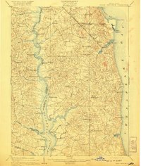
1910 Map of Prince Frederick
USGS Topo · Published 1921About this map
The Patuxent River serves as the western lifeline for Calvert County in the early twentieth century, defining a landscape of tobacco landings and river commerce. This survey captures a period when maritime transit remained central to local life, evidenced by the numerous wharves and crossings such as Lyon's Cr. Wharf, White Landing, and Magruder Ferry. While the river provided traditional transport, the Chesapeake Beach Ry. signals the arrival of the rail era, cutting across the peninsula to the burgeoning resort at Chesapeake Beach.
Find a feature on this map
65 named features on this map. Tap any name to fly to it.
Don’t see what you’re looking for? This feature index may not catch every label — zoom into the map to look around manually.
Map Details
Editions of this 1910 Prince Frederick Map
3 editions found
Other maps of this area

1892 · Leonardtown
USGS Topo · 1:62,500

1892 · Drum Point
USGS Topo · 1:62,500

1892 · Prince Frederick
USGS Topo · 1:62,500

1892 · Brandywine
USGS Topo · 1:62,500

1892 · Owensville
USGS Topo · 1:62,500

1892 · Annapolis
USGS Topo · 1:62,500

1893 · Sharps Island
USGS Topo · 1:62,500

1894 · Wicomico
USGS Topo · 1:62,500

1895 · Prince Frederick
USGS Topo · 1:62,500

1895 · Wicomico
USGS Topo · 1:62,500