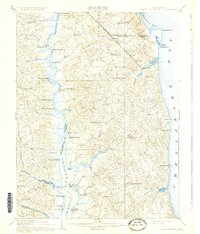
1910 Map of Prince Frederick
USGS Topo · Published 1931About this map
Prince Frederick and the surrounding Calvert County landscape are defined by their position between the deep waters of the Chesapeake Bay and the winding Patuxent River. At the turn of the century, the region relied heavily on maritime and riverine transport, evidenced by a dense network of landings and wharves such as Milltown Landing, White Landing, and Leitch Wharf. The interior terrain is a maze of creek valleys including Hunting Creek and Hall Creek, where small settlements like Huntingtown and Sunderland served as local hubs.
Find a feature on this map
63 named features on this map. Tap any name to fly to it.
Don’t see what you’re looking for? This feature index may not catch every label — zoom into the map to look around manually.
Map Details
Editions of this 1910 Prince Frederick Map
3 editions found
Other maps of this area

1892 · Leonardtown
USGS Topo · 1:62,500

1892 · Drum Point
USGS Topo · 1:62,500

1892 · Prince Frederick
USGS Topo · 1:62,500

1892 · Brandywine
USGS Topo · 1:62,500

1892 · Owensville
USGS Topo · 1:62,500

1892 · Annapolis
USGS Topo · 1:62,500

1893 · Sharps Island
USGS Topo · 1:62,500

1894 · Wicomico
USGS Topo · 1:62,500

1895 · Prince Frederick
USGS Topo · 1:62,500

1895 · Wicomico
USGS Topo · 1:62,500