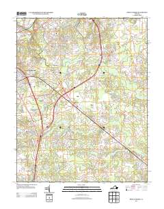
2013 Map of Prince George
USGS Topo · Published 2013About this map
Fort Lee occupies the northwestern portion of this region, characterized by a complex of military infrastructure including Nowak Field and the Fort Lee Golf Course. The surrounding landscape is defined by the winding reaches of Blackwater Swamp and Second Swamp, which weave through numerous small residential developments. In the heart of the area, New Bohemia sits at a major crossroads, while Prince George serves as a focal point further east. To the south, the Petersburg Jail Farm represents a significant institutional presence amid the natural hydrology of Jandls Pond and Dicks Br. The map reveals a suburban and institutional pattern of growth established around these extensive wetlands, with distinct neighborhoods like Timberly Heights, Lakemont, and Youngblood Acres bordering the major transportation corridors of Interstate 95 and US 460.
Find a feature on this map
154 named features on this map. Tap any name to fly to it.
Don’t see what you’re looking for? This feature index may not catch every label — zoom into the map to look around manually.
Map Details
Editions of this 2013 Prince George Map
This is the sole edition of this map. No revisions or reprints were ever made.
Other maps of this area

1894 · Bermuda Hundred
USGS Topo · 1:62,500

1894 · Petersburg
USGS Topo · 1:62,500

1918 · Charles City
USGS Topo · 1:62,500

1919 · Disputanta
USGS Topo · 1:62,500

1943 · Hopewell
USGS Topo · 1:31,680

1943 · Disputanta
USGS Topo · 1:31,680

1943 · Richmond
USGS Topo · 1:250,000

1944 · Reams
USGS Topo · 1:31,680
1944 · Chester
USGS Topo · 1:31,680
1944 · Petersburg
USGS Topo · 1:31,680