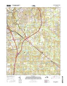
2016 Map of Prince George
USGS Topo · Published 2016About this map
Fort Lee occupies a central role in this landscape, showing the complex street grid of the military installation including Quartermaster Rd and various access roads. To the west, the eastern portions of Petersburg meet the protected grounds of the Petersburg National Battlefield, where historical defense lines are preserved amidst modern development. The map reveals a transition from the urban-military core to the rural agricultural character of Prince George and New Bohemia.
Find a feature on this map
167 named features on this map. Tap any name to fly to it.
Don’t see what you’re looking for? This feature index may not catch every label — zoom into the map to look around manually.
Map Details
Editions of this 2016 Prince George Map
This is the sole edition of this map. No revisions or reprints were ever made.
Other maps of this area

1894 · Bermuda Hundred
USGS Topo · 1:62,500

1894 · Petersburg
USGS Topo · 1:62,500

1918 · Charles City
USGS Topo · 1:62,500

1919 · Disputanta
USGS Topo · 1:62,500

1943 · Hopewell
USGS Topo · 1:31,680

1943 · Disputanta
USGS Topo · 1:31,680

1943 · Richmond
USGS Topo · 1:250,000

1944 · Reams
USGS Topo · 1:31,680
1944 · Chester
USGS Topo · 1:31,680
1944 · Petersburg
USGS Topo · 1:31,680