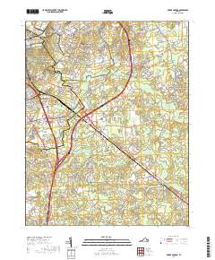
2019 Map of Prince George
USGS Topo · Published 2019About this map
Fort Lee dominates the northern landscape of this Virginia survey, showing a dense military infrastructure defined by roads like Bataan Rd and Inchon Rd. Adjacent to this installation lies the Petersburg National Battlefield, where the preservation of historical grounds meets the modern expansion of Petersburg. The transition from suburban development to the rural outskirts of Prince George Co is marked by significant wetlands, including the sprawling Blackwater Swamp and Second Swamp.
Find a feature on this map
163 named features on this map. Tap any name to fly to it.
Don’t see what you’re looking for? This feature index may not catch every label — zoom into the map to look around manually.
Map Details
Editions of this 2019 Prince George Map
This is the sole edition of this map. No revisions or reprints were ever made.
Other maps of this area

1894 · Bermuda Hundred
USGS Topo · 1:62,500

1894 · Petersburg
USGS Topo · 1:62,500

1918 · Charles City
USGS Topo · 1:62,500

1919 · Disputanta
USGS Topo · 1:62,500

1943 · Hopewell
USGS Topo · 1:31,680

1943 · Disputanta
USGS Topo · 1:31,680

1943 · Richmond
USGS Topo · 1:250,000

1944 · Reams
USGS Topo · 1:31,680
1944 · Chester
USGS Topo · 1:31,680
1944 · Petersburg
USGS Topo · 1:31,680