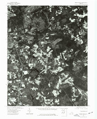
1974 Map of Prince George
USGS Topo · Published 1977About this map
Petersburg dominates the western portion of this 1974 orthophotoquad, showing a high-contrast overhead perspective of the city's residential and commercial density during the mid-1970s. The transition from the urban grid into the more sparsely developed landscapes of Prince George is clearly visible, with large tracts of woodland and cleared agricultural fields defining the eastern half of the sheet. This orthophotograph, derived from 1:76,000-scale aerial photography taken in April 1974, provides a visual record of the region's land use before late-century expansion. The sharp detail allows for the identification of transportation corridors and large-scale clearings that shaped the county at this time, offering a bridge between traditional topographic mapping and satellite imagery.
Find a feature on this map
2 named features on this map. Tap any name to fly to it.
Don’t see what you’re looking for? This feature index may not catch every label — zoom into the map to look around manually.
Map Details
Editions of this 1974 Prince George Map
This is the sole edition of this map. No revisions or reprints were ever made.
Other maps of this area

1894 · Bermuda Hundred
USGS Topo · 1:62,500

1894 · Petersburg
USGS Topo · 1:62,500

1918 · Charles City
USGS Topo · 1:62,500

1919 · Disputanta
USGS Topo · 1:62,500

1943 · Hopewell
USGS Topo · 1:31,680

1943 · Disputanta
USGS Topo · 1:31,680

1943 · Richmond
USGS Topo · 1:250,000

1944 · Reams
USGS Topo · 1:31,680
1944 · Chester
USGS Topo · 1:31,680
1944 · Petersburg
USGS Topo · 1:31,680