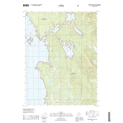
2018 Map of Prince Rupert D-3 NW
USGS Topo · Published 2018About this map
Tongass National Forest covers the vast majority of this coastal landscape, where the Alexander Archipelago meets the open waters of the Pacific Ocean. This survey reveals a deeply indented shoreline defined by the sprawling waters of Foggy Bay, which is sheltered from the sea by the De Long Islands. The terrain rises sharply from the saltwater to the summit of High Mtn, demonstrating the extreme relief typical of the Ketchikan Gateway region. The intricate coastline includes landmarks like Foggy Point, illustrating a maritime environment where access was primarily by water. The absence of roads or permanent settlements within these forest boundaries underscores the wilderness character of the area, where land use was dictated by the timber and fishing potential of the National Forest system.
Find a feature on this map
12 named features on this map. Tap any name to fly to it.
Don’t see what you’re looking for? This feature index may not catch every label — zoom into the map to look around manually.
Map Details
Editions of this 2018 Prince Rupert D-3 NW Map
This is the sole edition of this map. No revisions or reprints were ever made.
Other maps of this area

1951 · Prince Rupert
USGS Topo · 1:250,000

1952 · Ketchikan
USGS Topo · 1:250,000

1955 · Prince Rupert D-3
USGS Topo · 1:63,360

1955 · Ketchikan A-4
USGS Topo · 1:63,360
1955 · Prince Rupert D-4
USGS Topo · 1:63,360

1955 · Ketchikan A-3
USGS Topo · 1:63,360

1955 · Ketchikan
USGS Topo · 1:250,000

1959 · Prince Rupert
USGS Topo · 1:250,000

1964 · Prince Rupert
USGS Topo · 1:250,000
2017 · Ketchikan A-4 SE
USGS Topo · 1:25,000