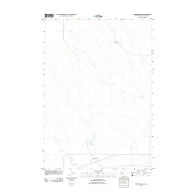
2012 Map of Princes Ranch
USGS Topo · Published 2012About this map
The high plains of Stanley County are defined by a network of drainage systems and isolated homesteads in this 2012 depiction of the West River region. The namesake Princes Ranch serves as a primary geographic anchor near the southern boundary, situated along a prominent east-west transportation corridor. Further north, the Haskins Ranch stands as another signifier of the sprawling cattle ranching heritage that has historically shaped this landscape. These ranching operations rely on the seasonal water provided by Willow Cr, which meanders diagonally across the majority of the terrain from the northwest to the southeast, and Lance Cr in the southwest. The mapping reveals a sparse settlement pattern characteristic of contemporary South Dakota rangeland, where named landmarks often reflect long-standing family holdings and the essential relationship between agriculture and the prairie waterways.
Find a feature on this map
4 named features on this map. Tap any name to fly to it.
Don’t see what you’re looking for? This feature index may not catch every label — zoom into the map to look around manually.
Map Details
Editions of this 2012 Princes Ranch Map
This is the sole edition of this map. No revisions or reprints were ever made.
Other maps of this area

1937 · Oahe
USGS Topo · 1:62,500

1953 · Oahe SW
USGS Topo · 1:24,000

1954 · Pierre
USGS Topo · 1:250,000

1958 · Pierre
USGS Topo · 1:250,000

1973 · Iron Post Buttes SW
USGS Topo · 1:24,000

1980 · Princes Ranch
USGS Topo · 1:25,000
1982 · Doty Ridge
USGS Topo · 1:24,000
1982 · Lacy
USGS Topo · 1:24,000

1982 · Hohrman Ranch
USGS Topo · 1:24,000

1983 · Standing Butte
USGS Topo · 1:24,000