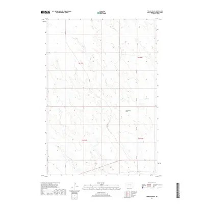
2017 Map of Princes Ranch
USGS Topo · Published 2017About this map
Princes Ranch serves as a primary marker of human activity in this expansive section of Stanley County. The landscape is defined by the dendritic drainage patterns of Willow Cr and Lance Creek, which carve through the high plains. A prominent geological depression known as Government Draw dominates the central-eastern portion of the map, illustrating the natural erosion processes typical of this South Dakota terrain. The area is gridded by a series of rural roads, including Greenfield and 267th Ave, which provide access across the township lines of t6n r27e and t6n r28e. This 2017 survey captures the modern cattle-ranching layout of the region, where wide-open spaces are punctuated by intermittent streams and family-held land tracts.
Find a feature on this map
13 named features on this map. Tap any name to fly to it.
Don’t see what you’re looking for? This feature index may not catch every label — zoom into the map to look around manually.
Map Details
Editions of this 2017 Princes Ranch Map
This is the sole edition of this map. No revisions or reprints were ever made.
Other maps of this area

1937 · Oahe
USGS Topo · 1:62,500

1953 · Oahe SW
USGS Topo · 1:24,000

1954 · Pierre
USGS Topo · 1:250,000

1958 · Pierre
USGS Topo · 1:250,000

1973 · Iron Post Buttes SW
USGS Topo · 1:24,000

1980 · Princes Ranch
USGS Topo · 1:25,000
1982 · Doty Ridge
USGS Topo · 1:24,000
1982 · Lacy
USGS Topo · 1:24,000

1982 · Hohrman Ranch
USGS Topo · 1:24,000

1983 · Standing Butte
USGS Topo · 1:24,000