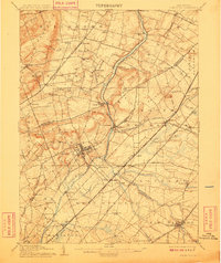
1906 Map of Princeton
USGS Topo · Published 1909About this map
Princeton serves as the academic and cultural heart of this Central New Jersey landscape, surrounded by a complex network of early 20th-century transportation routes. The Delaware and Raritan Canal mirrors the path of the Millstone River, winding through the center of the sheet past industrial and agricultural hubs like Griggstown and Blackwells Mills. The infrastructure of the era is remarkably dense, featuring competing rail lines such as the Philadelphia and Reading Railroad and the Pennsylvania Railroad. Small crossroads and villages like Blawenburg, Skillman, and Rocky Hill dot the terrain, illustrating the residential patterns that existed before mid-century suburban expansion. The inclusion of the Trenton and New Brunswick Electric Railroad highlights the importance of interurban transit in connecting these rural Somerset and Mercer County communities during a period of rapid regional growth.
Find a feature on this map
100 named features on this map. Tap any name to fly to it.
Don’t see what you’re looking for? This feature index may not catch every label — zoom into the map to look around manually.
Map Details
Editions of this 1906 Princeton Map
4 editions found
Other maps of this area

1888 · Plainfield
USGS Topo · 1:62,500

1888 · Bordentown
USGS Topo · 1:62,500

1888 · New Brunswick
USGS Topo · 1:62,500

1888 · Princeton
USGS Topo · 1:62,500

1888 · Cassville
USGS Topo · 1:62,500

1890 · High Bridge
USGS Topo · 1:62,500

1890 · Lambertville
USGS Topo · 1:62,500

1890 · Burlington
USGS Topo · 1:62,500

1891 · Somerville
USGS Topo · 1:62,500

1891 · Lambertville
USGS Topo · 1:62,500
Featured Places
- Hamilton Township, NJ
- Franklin Township, NJ
- South Brunswick, NJ
- North Brunswick Township, NJ
- Hillsborough Township, NJ