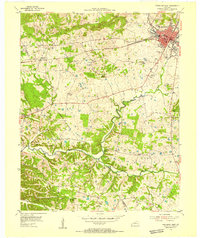
1954 Map of Princeton West
USGS Topo · Published 1955About this map
Princeton serves as the focal point of this mid-century Western Kentucky landscape, where the Illinois Central railroad cuts a horizontal path across the karst topography of Caldwell County. The town is detailed with civic infrastructure of the era, including the Caldwell County Hospital, Butler High Sch, and the Princeton Country Club Swimming Pool. To the west, the land transitions into a network of small rural communities and family landmarks, such as Hopewell, Saratoga, and Hattaway Hill.
Find a feature on this map
48 named features on this map. Tap any name to fly to it.
Don’t see what you’re looking for? This feature index may not catch every label — zoom into the map to look around manually.
Map Details
Editions of this 1954 Princeton West Map
This is the sole edition of this map. No revisions or reprints were ever made.
Other maps of this area

1908 · Princeton
USGS Topo · 1:62,500

1910 · Princeton
USGS Topo · 1:62,500

1928 · Eddyville
USGS Topo · 1:48,000

1931 · Eddyville
USGS Topo · 1:62,500

1936 · Eddyville
USGS Topo · 1:48,000

1936 · Mont
USGS Topo · 1:24,000

1936 · Golden Pond
USGS Topo · 1:48,000

1949 · Paducah
USGS Topo · 1:250,000

1950 · Paducah
USGS Topo · 1:250,000
1950 · Mont
USGS Topo · 1:24,000