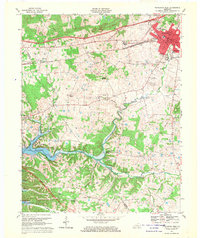
1967 Map of Princeton West
USGS Topo · Published 1970About this map
The county seat of Princeton serves as the hub for this 1967 survey, where the Illinois Central and the Western Kentucky Parkway intersect. The city’s institutional core is clearly defined, including the Courthouse, City Hall, and the County High School, while residential growth extends toward the Princeton Country Club. To the west and south, the landscape transitions into a network of small family-named ridges and hollows, such as Hopewell Hill and Sand Hollow, revealing a rural fabric of dispersed homesteads and local meeting places.
Find a feature on this map
56 named features on this map. Tap any name to fly to it.
Don’t see what you’re looking for? This feature index may not catch every label — zoom into the map to look around manually.
Map Details
Editions of this 1967 Princeton West Map
This is the sole edition of this map. No revisions or reprints were ever made.
Other maps of this area

1908 · Princeton
USGS Topo · 1:62,500

1910 · Princeton
USGS Topo · 1:62,500

1928 · Eddyville
USGS Topo · 1:48,000

1931 · Eddyville
USGS Topo · 1:62,500

1936 · Eddyville
USGS Topo · 1:48,000

1936 · Mont
USGS Topo · 1:24,000

1936 · Golden Pond
USGS Topo · 1:48,000

1949 · Paducah
USGS Topo · 1:250,000

1950 · Paducah
USGS Topo · 1:250,000
1950 · Mont
USGS Topo · 1:24,000