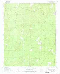
1973 Map of Princeton West
USGS Topo · Published 1975About this map
Princeton and its surrounding rural landscapes in Dallas County are defined by a network of sluggish waterways and small country congregations. The terrain is a complex drainage basin for the West Fork Hall Creek and Alsobrook Slough, where the land is frequently broken by sloughs and branches. Long-established community centers are marked by rural houses of worship such as Mt Zion Ch and Macedonia Ch, which are often accompanied by family and community burial grounds like Henderson Cem.
Find a feature on this map
30 named features on this map. Tap any name to fly to it.
Don’t see what you’re looking for? This feature index may not catch every label — zoom into the map to look around manually.
Map Details
Editions of this 1973 Princeton West Map
2 editions found
Other maps of this area

1903 · Camden
USGS Topo · 1:125,000

1953 · El Dorado
USGS Topo · 1:250,000

1955 · Little Rock
USGS Topo · 1:250,000

1956 · Little Rock
USGS Topo · 1:250,000

1957 · El Dorado
USGS Topo · 1:250,000

1958 · El Dorado
USGS Topo · 1:250,000

1960 · El Dorado
USGS Topo · 1:250,000

1960 · Little Rock
USGS Topo · 1:250,000

1964 · Little Rock
USGS Topo · 1:250,000
1965 · Manning
USGS Topo · 1:24,000