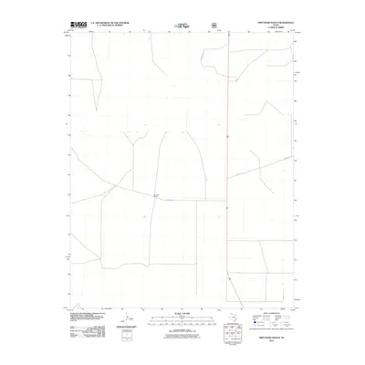
2010 Map of Pritchard Ranch
USGS Topo · Published 2010About this map
Pritchard Ranch serves as the primary named focal point for this section of the Texas Panhandle, situated within a landscape defined by expansive agricultural or ranching partitions. The transportation network in this corner of Dallam County consists of a sparse, rectilinear grid of local roads, including Pritchard Ln, Lawrence Ln, and Bowers Ln. These routes facilitate movement across the open plains, connecting isolated homesteads and ranching operations to larger regional arteries. The layout reflects a contemporary era of managed land use, where the placement of Att Ln and other named corridors underscores the importance of accessibility in this high-plains environment.
Find a feature on this map
5 named features on this map. Tap any name to fly to it.
Don’t see what you’re looking for? This feature index may not catch every label — zoom into the map to look around manually.
Map Details
Editions of this 2010 Pritchard Ranch Map
This is the sole edition of this map. No revisions or reprints were ever made.
Other maps of this area

1954 · Dalhart
USGS Topo · 1:250,000

1958 · Dalhart
USGS Topo · 1:250,000

1962 · Dalhart
USGS Topo · 1:250,000

1973 · Stratford 2 NW
USGS Topo · 1:24,000

1973 · Tovrea Ranch
USGS Topo · 1:24,000

1973 · Bolin NE
USGS Topo · 1:24,000

1973 · Bolin
USGS Topo · 1:24,000
1973 · Coldwater West
USGS Topo · 1:24,000

1973 · Coldwater East
USGS Topo · 1:24,000
1973 · Pritchard Ranch
USGS Topo · 1:24,000