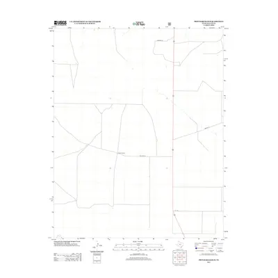
2012 Map of Pritchard Ranch
USGS Topo · Published 2012About this map
Pritchard Ranch serves as the central namesake for this high plains area in the Texas Panhandle. The landscape is defined by a sparse but precise network of rural routes, including Pritchard Ln and Lawrence Ln, which facilitate movement across the open expanse of Dallam County. This 2012 survey by the U.S. Geological Survey reflects the enduring agricultural and ranching character of the region. The grid-like arrangement of roads such as A T T Ln and Bowers Ln indicates a highly organized division of land, typical of the late 20th and early 21st-century ranching infrastructure. The lack of dense settlement emphasizes the remote, large-scale property holdings that characterize this portion of the Texas-New Mexico borderlands.
Find a feature on this map
5 named features on this map. Tap any name to fly to it.
Don’t see what you’re looking for? This feature index may not catch every label — zoom into the map to look around manually.
Map Details
Editions of this 2012 Pritchard Ranch Map
This is the sole edition of this map. No revisions or reprints were ever made.
Other maps of this area

1954 · Dalhart
USGS Topo · 1:250,000

1958 · Dalhart
USGS Topo · 1:250,000

1962 · Dalhart
USGS Topo · 1:250,000

1973 · Stratford 2 NW
USGS Topo · 1:24,000

1973 · Tovrea Ranch
USGS Topo · 1:24,000

1973 · Bolin NE
USGS Topo · 1:24,000

1973 · Bolin
USGS Topo · 1:24,000
1973 · Coldwater West
USGS Topo · 1:24,000

1973 · Coldwater East
USGS Topo · 1:24,000
1973 · Pritchard Ranch
USGS Topo · 1:24,000