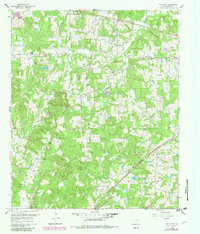
1960 Map of Pritchett
USGS Topo · Published 1982About this map
Upshur County's agricultural and rural landscape is defined here by a dense network of country churches and small, crossroads settlements during the mid-twentieth century. The St Louis Southwestern railroad cuts diagonally across the southern half of the sheet, providing a vital transport link for the community of Pritchett. Smaller hamlets like Kelsey, Rosewood, and Enoch are connected by winding roads through hilly terrain, where landmarks such as Peter Hayes Hill rise above the surrounding creek basins. The prominence of family-named features and religious sites, including Johnson Chapel and the Kelsey Cemetery, highlights a settled, multi-generational community structure. Natural drainage is shaped by Kelsey Creek and Glade Creek, with numerous smaller tributaries like Hopewell Branch and Little Oak Creek feeding into the local water system. A single Landing Strip and a utility Pipeline represent the modern infrastructure overlaying this established East Texas landscape.
Find a feature on this map
35 named features on this map. Tap any name to fly to it.
Don’t see what you’re looking for? This feature index may not catch every label — zoom into the map to look around manually.
Map Details
Editions of this 1960 Pritchett Map
3 editions found
Other maps of this area

1956 · Tyler
USGS Topo · 1:250,000

1960 · Shady Grove
USGS Topo · 1:24,000

1960 · Hawkins
USGS Topo · 1:24,000

1960 · Big Sandy
USGS Topo · 1:24,000

1960 · Pritchett
USGS Topo · 1:24,000

1960 · Bettie
USGS Topo · 1:24,000

1960 · Gilmer
USGS Topo · 1:24,000

1960 · Thomas
USGS Topo · 1:24,000

1960 · Rhonesboro
USGS Topo · 1:24,000

1960 · Gladewater
USGS Topo · 1:24,000