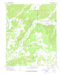
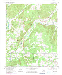
1972 Map of Proctor
USGS Topo · Published 1974About this map
The Illinois River winds through the western edge of this Ozark foothills landscape, meeting the waters of Baron Fork near the settlement of Eldon. This early 1970s survey captures a rural landscape where small communities like Proctor and Briggs are connected by winding valley roads and the legacy of earlier transportation routes, such as the Old Railroad Grade that parallels the river. The area is defined by its topographic relief, featuring prominent heights like Proctor Mountain and Eldon Mountain that rise above a network of hollows, including Pumpkin Hollow and Mining Camp Hollow. Local life centers on landmarks like Camp Egan, Oakdale Ch, and Proctor Ch, while the eastern portion of the sheet follows the Cherokee Co Adair Co line. The presence of a Gaging Station and various springs along the Wall Trip Branch indicate the importance of water resources to the local economy and environment during this era.
Find a feature on this map
28 named features on this map. Tap any name to fly to it.
Don’t see what you’re looking for? This feature index may not catch every label — zoom into the map to look around manually.
Map Details
Editions of this 1972 Proctor Map
2 editions found
Other maps of this area

1898 · Tahlequah
USGS Topo · 1:125,000

1899 · Siloam Springs
USGS Topo · 1:125,000

1901 · Tahlequah
USGS Topo · 1:125,000

1903 · Siloam Springs
USGS Topo · 1:125,000

1904 · Siloam Springs
USGS Topo · 1:125,000

1905 · Tahlequah
USGS Topo · 1:125,000

1946 · Fort Smith
USGS Topo · 1:250,000

1954 · Tulsa
USGS Topo · 1:250,000

1958 · Tulsa
USGS Topo · 1:250,000

1963 · Tulsa
USGS Topo · 1:250,000