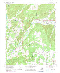
1972 Map of Proctor
USGS Topo · Published 1983About this map
Proctor and the surrounding borderlands of Cherokee and Adair counties appear here in a state of rural transition during the early 1970s. The landscape is defined by the winding course of the Illinois River and Baron Fork, where local infrastructure like the Gaging Station and various river crossings supported small agricultural communities. Religious and social centers are prominently marked, including the Long Spring Ch, Oakdale Ch, and Proctor Ch, which served as anchors for dispersed settlements like Pumpkin Center and Titanic.
Find a feature on this map
36 named features on this map. Tap any name to fly to it.
Don’t see what you’re looking for? This feature index may not catch every label — zoom into the map to look around manually.
Map Details
Editions of this 1972 Proctor Map
2 editions found
Other maps of this area

1898 · Tahlequah
USGS Topo · 1:125,000

1899 · Siloam Springs
USGS Topo · 1:125,000

1901 · Tahlequah
USGS Topo · 1:125,000

1903 · Siloam Springs
USGS Topo · 1:125,000

1904 · Siloam Springs
USGS Topo · 1:125,000

1905 · Tahlequah
USGS Topo · 1:125,000

1946 · Fort Smith
USGS Topo · 1:250,000

1954 · Tulsa
USGS Topo · 1:250,000

1958 · Tulsa
USGS Topo · 1:250,000

1963 · Tulsa
USGS Topo · 1:250,000