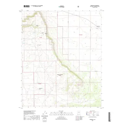
2020 Map of Progresso
USGS Topo · Published 2020About this map
Progresso occupies a high-desert landscape in Torrance County, centered around a small settlement and its associated Progresso Cem. The terrain is defined by the massive Mesa de los Jumanos, which drops off into a series of deep drainages including Bell Tank Canyon and Pueblo Blanco Canyon. This 2020 survey reveals a landscape geared toward cattle ranching and water management, with numerous named catchments like East Willard Tank, Wiltbank Tank, and Ruins Tank scattered across the high plains and canyon floors. A portion of the Cibola National Forest covers the central southern region, where the rugged topography of Martin Canyon cuts through the limestone and sandstone layers of the mesa. The road network, including Progresso Rd and several county routes, follows the natural contours of the land, providing access to this sparsely populated region of central New Mexico.
Find a feature on this map
25 named features on this map. Tap any name to fly to it.
Don’t see what you’re looking for? This feature index may not catch every label — zoom into the map to look around manually.
Map Details
Editions of this 2020 Progresso Map
This is the sole edition of this map. No revisions or reprints were ever made.
Other maps of this area

1917 · Estancia
USGS Topo · 1:125,000

1954 · Fort Sumner
USGS Topo · 1:250,000

1954 · Socorro
USGS Topo · 1:250,000

1956 · Mountainair
USGS Topo · 1:62,500

1958 · Socorro
USGS Topo · 1:250,000

1958 · Fort Sumner
USGS Topo · 1:250,000

1962 · Socorro
USGS Topo · 1:250,000

1972 · Gran Quivira
USGS Topo · 1:24,000
1972 · Round Top
USGS Topo · 1:24,000

1978 · Laguna Del Perro South
USGS Topo · 1:24,000