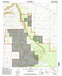
1995 Map of Progresso
USGS Topo · Published 1998About this map
Mesa Loma dominates the northwestern portion of this 1995 revision, where the high desert terrain transitions into the protected lands of the Cibola National Forest. The map documents a landscape defined by ranching and water management, featuring numerous named points of interest for genealogists and local historians, including the Hansen Ranch, DeVaney Ranch, and Brown Ranch. The settlement of Progresso and the Willard surveying point mark the primary hubs of activity in this arid New Mexico interior. In the south, the archaeological and historical significance of the region is signaled by the presence of Pueblo Blanco and several landmarks such as the Ruins Windmill and Ruins Tank. Throughout the quadrangle, a network of windmills and tanks like Willbank Tank and the Joy Windmill illustrate the vital importance of water access in maintaining these high-elevation rangelands.
Find a feature on this map
35 named features on this map. Tap any name to fly to it.
Don’t see what you’re looking for? This feature index may not catch every label — zoom into the map to look around manually.
Map Details
Editions of this 1995 Progresso Map
This is the sole edition of this map. No revisions or reprints were ever made.
Other maps of this area

1917 · Estancia
USGS Topo · 1:125,000

1954 · Fort Sumner
USGS Topo · 1:250,000

1954 · Socorro
USGS Topo · 1:250,000

1956 · Mountainair
USGS Topo · 1:62,500

1958 · Socorro
USGS Topo · 1:250,000

1958 · Fort Sumner
USGS Topo · 1:250,000

1962 · Socorro
USGS Topo · 1:250,000

1972 · Gran Quivira
USGS Topo · 1:24,000
1972 · Round Top
USGS Topo · 1:24,000

1978 · Laguna Del Perro South
USGS Topo · 1:24,000