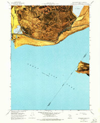
1968 Map of Promontory Point
USGS Topo · Published 1972About this map
Promontory Mountains dominate the northern landscape of this orthophotomap, terminating at the edge of the Great Salt Lake. This 1968-era survey illustrates the industrial and transportation infrastructure required to navigate and utilize this saline environment, notably the Southern Pacific railroad line and the Private (Lucin Cutoff) causeway. The settlement of Saline and the geographic Promontory Point serve as key landmarks along the southern tip of the peninsula, where the landscape is defined by extensive Mud Flats and specialized Salt Evaporators.
Find a feature on this map
22 named features on this map. Tap any name to fly to it.
Don’t see what you’re looking for? This feature index may not catch every label — zoom into the map to look around manually.
Map Details
Editions of this 1968 Promontory Point Map
2 editions found
Other maps of this area

1954 · Brigham City
USGS Topo · 1:250,000

1955 · Willard Spur
USGS Topo · 1:24,000

1955 · Fremont Island
USGS Topo · 1:24,000

1958 · Brigham City
USGS Topo · 1:250,000

1962 · Brigham City
USGS Topo · 1:250,000

1968 · Indian Cove
USGS Topo · 1:24,000

1968 · Pokes Point
USGS Topo · 1:24,000

1968 · Promontory Point
USGS Topo · 1:24,000

1968 · Fremont Island SW
USGS Topo · 1:24,000

1968 · Carrington Island
USGS Topo · 1:24,000