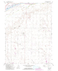
1962 Map of Prosser
USGS Topo · Published 1993About this map
Platte River braided channels define the northern reaches of this landscape on the border of Hall and Adams Counties. The river splits around large landforms such as Jackson Island and Elm Island, with the Middle Channel and South Channel creating a complex waterway system. South of the river, the terrain rises toward Topeka Peak and the township of Martin, where a Townhall and local sandpits indicate the small-scale infrastructure of the early 1960s.
Find a feature on this map
22 named features on this map. Tap any name to fly to it.
Don’t see what you’re looking for? This feature index may not catch every label — zoom into the map to look around manually.
Map Details
Editions of this 1962 Prosser Map
2 editions found

Other maps of this area

1892 · Grand Island
USGS Topo · 1:62,500

1894 · Kenesaw
USGS Topo · 1:62,500

1895 · Grand Island
USGS Topo · 1:62,500

1895 · Wood River
USGS Topo · 1:62,500

1896 · Wood River
USGS Topo · 1:125,000

1898 · Grand Island
USGS Topo · 1:125,000

1955 · Grand Island
USGS Topo · 1:250,000

1957 · Grand Island
USGS Topo · 1:250,000

1958 · Grand Island
USGS Topo · 1:250,000

1962 · Denman
USGS Topo · 1:24,000