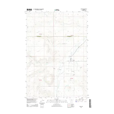
2014 Map of Pryor
USGS Topo · Published 2014About this map
Pryor serves as the central hub of this Big Horn County landscape, situated near the transition from the Yellowstone and Big Horn County line. The settlement is defined by its connection to the surrounding terrain via Hwy 91 and Pryor Rd, while local life is anchored by landmarks like Smith Baptist Dr and Makpua Ave. For those tracing family ties to the area, several distinct burial sites are noted, including Big Day Cem, Pryor Cem, and Singgood Cem near the small locale of Singgood.
Find a feature on this map
31 named features on this map. Tap any name to fly to it.
Don’t see what you’re looking for? This feature index may not catch every label — zoom into the map to look around manually.
Map Details
Editions of this 2014 Pryor Map
This is the sole edition of this map. No revisions or reprints were ever made.
Other maps of this area

1893 · Huntley
USGS Topo · 1:125,000

1954 · Billings
USGS Topo · 1:250,000

1957 · Billings
USGS Topo · 1:250,000

1958 · Billings
USGS Topo · 1:250,000

1967 · Castle Rocks
USGS Topo · 1:24,000

1967 · Deep Creek
USGS Topo · 1:24,000

1967 · Pryor
USGS Topo · 1:24,000

1967 · Deep Creek SW
USGS Topo · 1:24,000

1967 · Section House Draw
USGS Topo · 1:24,000
1967 · Mossmain SW
USGS Topo · 1:24,000