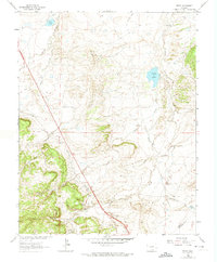
1963 Map of Pryor
USGS Topo · Published 1974About this map
Pryor and the neighboring settlements of Monson and Lester occupy the lower slopes of the Southern Colorado coal fields during the early 1960s. The landscape is defined by the heavy footprint of early 20th-century industry, evidenced by the prominent Colorado and Southern Railroad Grade and numerous Mines scattered throughout the rugged topography. The presence of a Mine Dump near the main settlement areas points to the extractive heritage that shaped these communities along the border of Huerfano and Las Animas Counties.
Find a feature on this map
24 named features on this map. Tap any name to fly to it.
Don’t see what you’re looking for? This feature index may not catch every label — zoom into the map to look around manually.
Map Details
Editions of this 1963 Pryor Map
3 editions found
Other maps of this area

1891 · Walsenburg
USGS Topo · 1:125,000

1891 · Spanish Peaks
USGS Topo · 1:125,000

1893 · Spanish Peaks
USGS Topo · 1:125,000

1894 · Walsenburg
USGS Topo · 1:125,000

1895 · Spanish Peaks
USGS Topo · 1:125,000

1897 · Walsenburg
USGS Topo · 1:125,000

1897 · Spanish Peaks
USGS Topo · 1:125,000

1900 · Spanish Peaks
USGS Topo · 1:125,000

1900 · Walsenburg
USGS Topo · 1:125,000

1954 · Trinidad
USGS Topo · 1:250,000