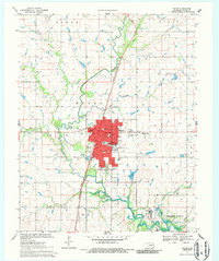
1970 Map of Pryor
USGS Topo · Published 1986About this map
Pryor (Pryor Creek) serves as the clear anchor of this Mayes County landscape, depicted here during a period of established civic growth and industrial development. The city plan is densely detailed, featuring numerous educational institutions such as Roosevelt Sch and Lincoln Sch, alongside landmarks like the Courthouse and the Whitaker State Childrens Home. The Missouri-Kansas-Texas railroad corridor bisects the terrain, running parallel to the meandering course of Pryor Creek. To the south, the landscape shifts toward industrial and utility infrastructure, marked by a Chemical Plant and an Aqueduct system that feeds into the northern reaches of the Fort Gibson Reservoir. This 1970 field-checked survey captures the transition from the concentrated residential grid of the town to the managed water and power resources of the surrounding river valley.
Find a feature on this map
42 named features on this map. Tap any name to fly to it.
Don’t see what you’re looking for? This feature index may not catch every label — zoom into the map to look around manually.
Map Details
Editions of this 1970 Pryor Map
2 editions found
Other maps of this area

1896 · Pryor
USGS Topo · 1:125,000

1901 · Pryor
USGS Topo · 1:125,000

1954 · Tulsa
USGS Topo · 1:250,000

1958 · Tulsa
USGS Topo · 1:250,000

1963 · Tulsa
USGS Topo · 1:250,000

1969 · Adair
USGS Topo · 1:24,000
1970 · Bushyhead
USGS Topo · 1:24,000
1970 · Osage Hills
USGS Topo · 1:24,000
1970 · Chouteau NW
USGS Topo · 1:24,000
1970 · Chouteau
USGS Topo · 1:24,000