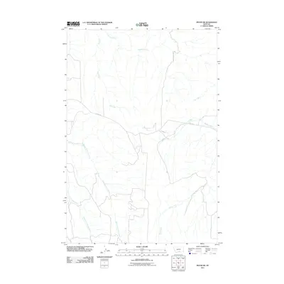
2011 Map of Pryor NW
USGS Topo · Published 2011About this map
Wolf Creek and Cottonwood Creek carve through this Montana landscape, defining the local drainage patterns south of the Yellowstone River. The area is characterized by a sparse road network, primarily consisting of Pryor Rd, E Pryor Rd, and Edgar Rd, which facilitate travel through the vast open spaces of Yellowstone County. Several significant tributaries, including Plum Creek, Macheta Creek, and Willow Creek, create a dendritic network across the terrain. Farther south, the headwaters of the North Fork Fivemile Creek and Middle Fork Fivemile Creek emerge, illustrating the complex hydrography of the region. The map captures the intersection of these vital waterways and the rural infrastructure that supports the local ranching and agricultural heritage.
Find a feature on this map
10 named features on this map. Tap any name to fly to it.
Don’t see what you’re looking for? This feature index may not catch every label — zoom into the map to look around manually.
Map Details
Editions of this 2011 Pryor NW Map
This is the sole edition of this map. No revisions or reprints were ever made.
Other maps of this area

1954 · Billings
USGS Topo · 1:250,000

1956 · Silesia
USGS Topo · 1:24,000

1956 · Edgar
USGS Topo · 1:24,000

1957 · Billings
USGS Topo · 1:250,000

1958 · Billings
USGS Topo · 1:250,000

1967 · Castle Rocks
USGS Topo · 1:24,000

1967 · Pryor
USGS Topo · 1:24,000

1967 · Section House Draw
USGS Topo · 1:24,000

1967 · Bluewater
USGS Topo · 1:24,000
1967 · Mossmain SW
USGS Topo · 1:24,000