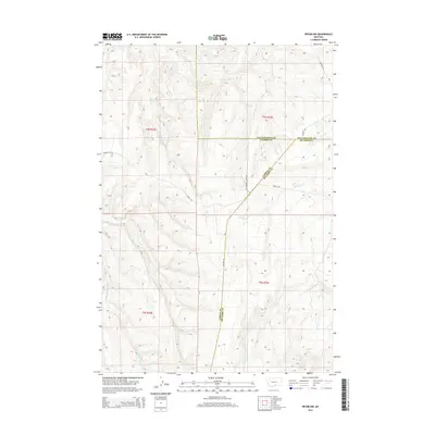
2014 Map of Pryor NW
USGS Topo · Published 2014About this map
The high plains of south-central Montana meet a complex drainage network where Yellowstone, Carbon, and Big Horn counties converge. This landscape is defined by the seasonal flow of waters toward the Yellowstone River basin, most notably via Cottonwood Cr and Wolf Cr. The map reveals the organized grid of the Public Land Survey System, with township and range lines such as t4s r24e and t5s r25e providing the skeletal structure for land ownership and management in this rural expanse. A sparse but essential road network, including Edgar Rd and Sheller Rd, follows the natural contours of the terrain and the established section lines, connecting the various coulees and creek beds. Further south, the map details the headwaters of the Fivemile Creek system, including the N Fork Fivemile Cr and Middle Fork Fivemile Cr, illustrating the vital role of these drainage ways in an arid environment.
Find a feature on this map
19 named features on this map. Tap any name to fly to it.
Don’t see what you’re looking for? This feature index may not catch every label — zoom into the map to look around manually.
Map Details
Editions of this 2014 Pryor NW Map
This is the sole edition of this map. No revisions or reprints were ever made.
Other maps of this area

1954 · Billings
USGS Topo · 1:250,000

1956 · Silesia
USGS Topo · 1:24,000

1956 · Edgar
USGS Topo · 1:24,000

1957 · Billings
USGS Topo · 1:250,000

1958 · Billings
USGS Topo · 1:250,000

1967 · Castle Rocks
USGS Topo · 1:24,000

1967 · Pryor
USGS Topo · 1:24,000

1967 · Section House Draw
USGS Topo · 1:24,000

1967 · Bluewater
USGS Topo · 1:24,000
1967 · Mossmain SW
USGS Topo · 1:24,000