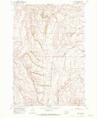
1967 Map of Pryor NW
USGS Topo · Published 1971About this map
The Crow Indian Reservation Boundary cuts through this landscape of the late 1960s, marking a significant geopolitical divide across the rolling hills of Carbon, Yellowstone, and Big Horn counties. This area is defined by a dense network of drainage systems, with Wolf Creek and Cottonwood Creek carving deep paths through the northern sections. The southern half of the map is dominated by the headwaters of the Fivemile Creek system, including the North Fork and Middle Fork. Numerous unnamed springs are indicated throughout the terrain, signaling the vital water sources that supported livestock and ranching operations in this part of Montana. The lack of concentrated settlements highlights the rural character of the region, where land use was primarily governed by the natural topography and the historical boundaries of the reservation.
Find a feature on this map
11 named features on this map. Tap any name to fly to it.
Don’t see what you’re looking for? This feature index may not catch every label — zoom into the map to look around manually.
Map Details
Editions of this 1967 Pryor NW Map
This is the sole edition of this map. No revisions or reprints were ever made.
Other maps of this area

1954 · Billings
USGS Topo · 1:250,000

1956 · Silesia
USGS Topo · 1:24,000

1956 · Edgar
USGS Topo · 1:24,000

1957 · Billings
USGS Topo · 1:250,000

1958 · Billings
USGS Topo · 1:250,000

1967 · Castle Rocks
USGS Topo · 1:24,000

1967 · Pryor
USGS Topo · 1:24,000

1967 · Section House Draw
USGS Topo · 1:24,000

1967 · Bluewater
USGS Topo · 1:24,000
1967 · Mossmain SW
USGS Topo · 1:24,000